


The area that the US EPA calls the Monument Valley Area is situated in northeastern Arizona and southeastern Utah. The Monument Valley Area includes Baby Rocks Mesa, Cane Valley, Dennehotso, Double Arch Canyon, Mexican Hat, Monument Valley Park, Oljato, Shonto, Wetherill Mesa, and Agathla Peak. Note: Satellite imagery is retrieved from Google Maps, so if they don’t immediately load, refresh the page.
| Name of Water Source | Picture of Water Source | Satellite Map of Water Source |
|---|---|---|
|
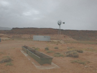
Tank 8AI-3 Longitude: -110 13 51.923 Latitude: 37 2 32.83681 View Larger Map |

|
|
|
Tank 8AI-1 Longitude: -110 18 34.589 Latitude: 37 1 17.04720 View Larger Map |
|
|
|
Goulding Well Longitude: -110 13 4.8168 Latitude: 37 0 17.62621 View Larger Map |

|
|
|
Tank 8A-299 Longitude: -110 17 29.530 Latitude: 36 56 50.6478 View Larger Map |

|
|
|
Shallow Well-Adakai Longitude: -109 54 54.366 Latitude: 36 52 52.5528 View Larger Map |

|
|
|
Kiishzhinii-be-toh Spring Longitude: -109 51 58.602 Latitude: 36 55 36.3593 View Larger Map |

|
|
|
Kee Mi Kay Spring Longitude: -110 11 1.5587 Latitude: 36 40 23.9987 View Larger Map |

|
|
|
Tank 8A-138 Longitude: -110 9 7.85638 Latitude: 36 41 34.7219 View Larger Map |

|
|
|
Baby Rock Spring 8-44 Longitude: -110 3 13.2743 Latitude: 36 44 49.6547 View Larger Map |

|
|
|
Kayenta Chapter House Longitude: -110 15 17.050 Latitude: 36 43 27.9336 View Larger Map |

|
|
|
Tank 2K-305 Longitude: -110 34 29.954 Latitude: 36 46 41.8019 View Larger Map |

|
|
|
Aspen Spring Longitude: -110 31 8.1977 Latitude: 36 48 26.5362 View Larger Map |

|
|
|
Ramp Spring Longitude: -110 22 7.0776 Latitude: 36 56 53.3940 View Larger Map |

|
|
|
8A-P.H.S.-22 Spring Longitude: -110 15 55.235 Latitude: 36 51 16.8480 View Larger Map |

|
|
|
Well 8T-525 Longitude: -110 18 22.740 Latitude: 36 56 19.8743 View Larger Map |

|
|
|
Tank 8K-402 Longitude: -110 12 29.139 Latitude: 36 57 16.0674 View Larger Map |

|
|
|
Shallow Well El Capitan Longitude: -110 19 48.964 Latitude: 36 58 15.2357 View Larger Map |

|
|
|
Truck Cab Spring Longitude: -110 19 36.643 Latitude: 37 0 19.27800 View Larger Map |
|
|
|
Moonlight Water Longitude: -110 18 30.982 Latitude: 37 1 21.65761 View Larger Map |

|
|
|
Monument Valley High School Longitude: -110 10 42.511 Latitude: 37 0 20.16539 View Larger Map |
|
|
|
Tsiah Spring Longitude: -110 8 2.15520 Latitude: 36 55 41.3190 View Larger Map |

|
|
|
Monument Valley Park Longitude: -110 6 48.3239 Latitude: 36 58 53.5044 View Larger Map |

|
|
|
Sand Spring Longitude: -110 3 19.8377 Latitude: 36 55 55.8119 View Larger Map |

|
|
|
Tank-East of Chapter Longitude: -109 48 29.801 Latitude: 36 53 54.5862 View Larger Map |
|
|
|
Tank 8T-519 Longitude: -109 46 23.957 Latitude: 36 55 24.8562 View Larger Map |
|
|
|
Artesian Well 613 Longitude: -109 51 50.499 Latitude: 36 55 32.6430 View Larger Map |

|
|
|
Stockpile Well Longitude: -109 51 54.831 Latitude: 36 56 10.0104 View Larger Map |

|
|
|
Tse-li-chee-hateh Spring Longitude: -109 50 40.450 Latitude: 37 1 12.07919 View Larger Map |

|
|
|
Monument Pass Well Longitude: -110 6 59.9004 Latitude: 37 2 7.366811 View Larger Map |

|
|
|
Shonto Chapter House Longitude: -110 38 40.300 Latitude: 36 35 38.9843 View Larger Map |
|
|